GPS Waypoints is a multi-purpose surveying application supporting the following generic use cases for both professional and personal activities:
- Surveying – field recording of Points, Paths or Areas for thematic mapping and planning. The Points are acquired and classified with thematic tags and photos. The Paths and Areas are sequence of points forming multi-lines or polygons that can determine distances, areas, perimeters and durations. The data collected can be exported for handling on a geographical information tool.
- Navigation – find a way from the current location to destination Points. Firstly, you need to import the target Points from coordinates or addresses. Then, you can explore the navigation features to obtain directions and distances to each point or to check the nearest one (sort by proximity).
- Tracking – background recording of outdoor activities or moving objects (i.e vehicles) into Paths (sequence of Points). The resulting Paths can be exported to a GPX file to be further analysed.
- Geodata analysis – analysing and processing geodata to obtain basic metrics (distances, areas, perimeters and durations) or advanced conversions using UTM projection or Regional Datums.
The Professional usage depends on the accuracy of the GNSS receiver that is being used. You can use an internal receiver (medium accuracy positioning) or an external receiver (higher accuracy). The most relevant professional sectors are:
- Agriculture & Forest – planning areas with field measurements, monitoring crops, infestation mapping and track vehicles during seeding;
- Real Estate & Construction – urban planning, property appraisal and construction mapping;
- Infrastructures – roads and utilities planning and maintenance;
- Emergencies – post-disaster mapping and disaster response support;
- Other – environment & biodiversity, natural resources, aerial vehicles, archaeology, health surveying, etc…
The Personal usage is typically satisfied with the accuracy provided by the smartphone’s internal receiver (while some demanding personal users may also use external receivers). The most common personal activities are:
- Outdoor entertainment – track exercise during hiking, cycling and running activities; plan or find control points in orienteering, etc…
- Travelling – save favourite spots, find my places and track my trip;
- Day-to-day life – meet me here, maintaining my homeland favourite Points-of-Interest.
Professional Activities
The professional activities are performed by specialists from various sectors (not only geographers), typically to perform land surveying, land areas and routes definition. Some real case studies from the most relevant sectors are presented hereafter.
Agriculture & Forest
The GPS Waypoints is being used in Agriculture for both planning and monitor cultivated areas. It is used to measure crops areas in order to estimate production (create Manual Polygons), measure and plot new tubing layouts of sugar maple trees pipes (create Manual Paths), identify and classify the infested trees on olive groves or cork farms (Use custom tags and photo attachment).
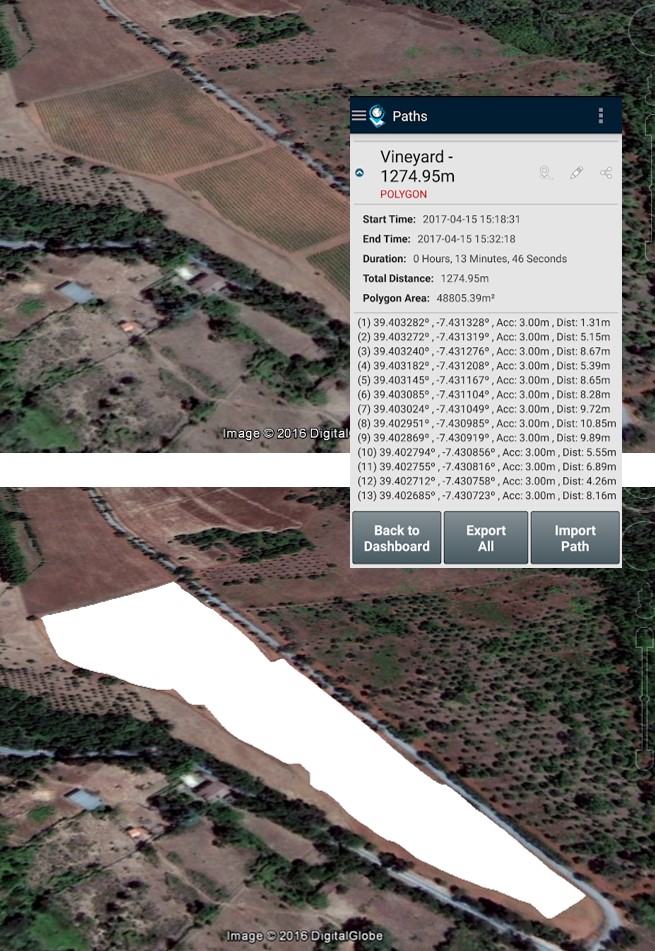 Define and measure a new plantation area Define and measure a new plantation area |
 Sugar Maple Trees Sugar Maple Treespipe planning |
 Olive Trees infestation monitoring Olive Trees infestation monitoring |
Real Estate & Construction
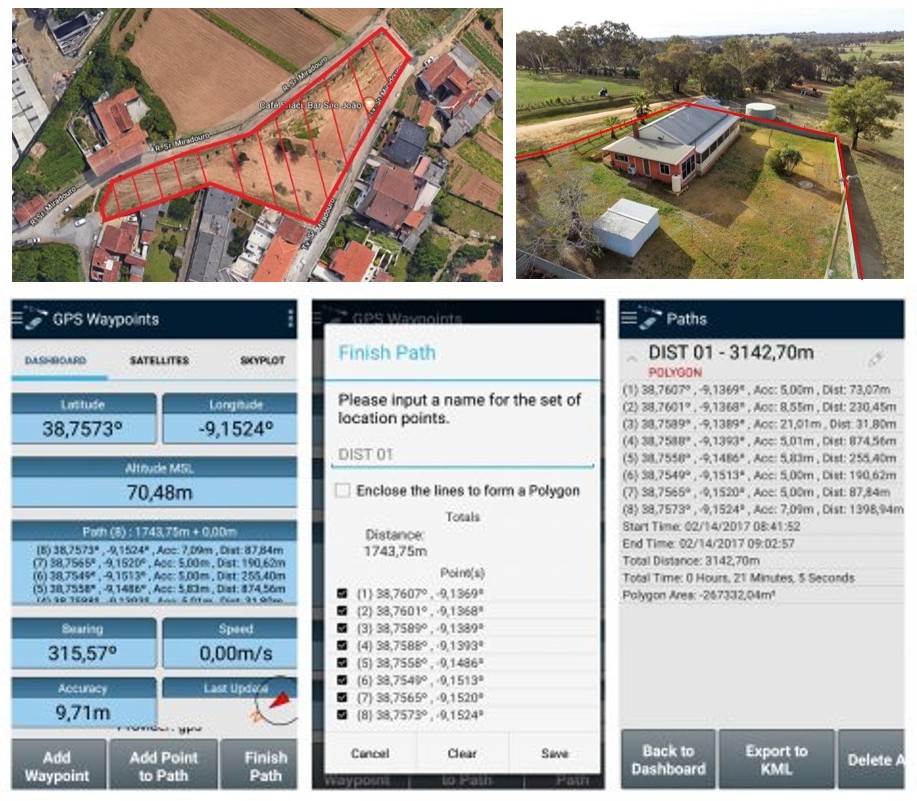
The tool is used in Real Estate to measure land properties by owners, evaluators or buyers in order to determine areas and borders of land properties for planning and valuation purposes. The user must collect sequential points of the land surroundings and close the path to build a polygonal area.
 |
 |
|
| Define and measure a land property area for sale or land-use change | Acquire control points with a precision RTK receiver in combination with total station measurements |
The tool is also used in urban planning to support land use mapping activities. The user collects the points on the field, tags them using his classification system and exports the results to validate the thematic classes or determine the mapping accuracy.
The combination of conventional survey instruments and high precision GPS is an advanced use case of GPS Waypoints. It can support topographic surveys for construction sites without requiring the know-how of a GNSS specialist.
Infrastructures
The tool can be used for planning network infrastructures and maintaining them for producing incident report data. Two known infrastructure use cases are the road pavement maintenance and the planning of electric distribution systems, as depicted in the figures below.
 |
 |
|
| Road pavement classification for maintenance | Planning medium-voltage and low-voltage distribution systems |
The road pavement maintenance professionals need to evaluate and classify the road status. They can identify pavements distresses with exact coordinates of the failures and associate a tag based on their own classification model. The model can be adapted for each country, using different levels of detailed. For instance, pavement distress model for asphalt concrete surfaces could be as simple as:
-
Cracking
-
Patching and Potholes
-
Surface Deformation
-
Surface defects
-
Miscellaneous Distresses
The planning of electric distribution systems needs to define in Autocad the new the medium-voltage and low-voltage networks and change the existing ones. The GPS Waypoints is used to collect the waypoints on the field, export them to KML for later conversion to Autocad (automatic export feature to Autocad will soon be available). The collected waypoints will support the drawing of new planning diagrams.
Emergencies
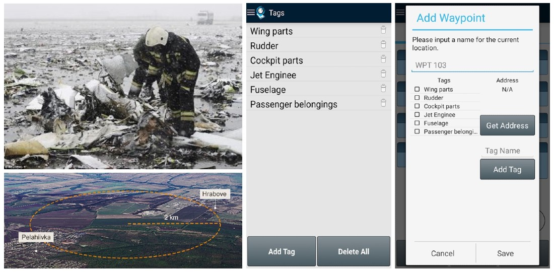
GPS Waypoints can help emergencies to map objects or incidents in a disaster area or eventually to support some disaster response activities.
 |
 |
|
| Disaster debris mapping | Locate the nearest fire hydrants from my area |
It can be usefull for mapping the object founds on post-disaster area since it allows collecting position and classifying the wreckage and other objects found. The application becomes particular relevant in activities that need to be fastly performed in a wide area, typically involving volunteers.
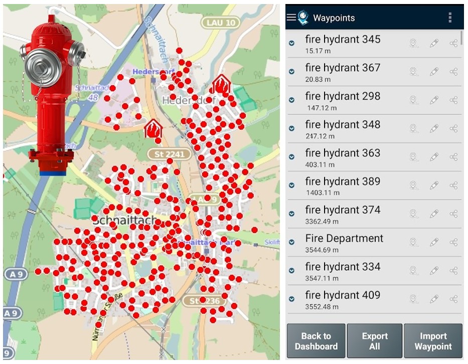
Another use case is to import rescue Points, such as the hydrant locations from a fire department. During the response time, the tool can support an emergency agent (e.g fireman) to get the nearest ones (sort Points by proximity) and obtain directions to each of them.
Personal activities
GPS Waypoints can also be used for personal entertainment, like outdoor activities, geocaching, travel and other non-professional activities. The usage is oriented to skillful e creatives users, that want to keep data privacy restricted to their handset and want to manage the surveying datasets.
Outdoor entertainment
 |
 |
|
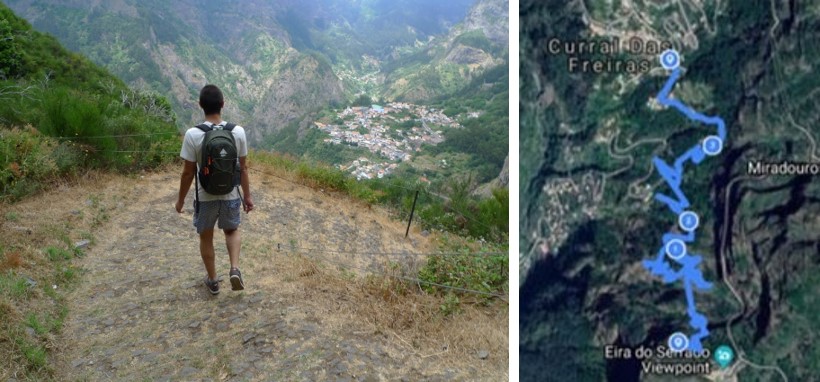
| Auto track a walking route with GPX export to MapMyFitness |
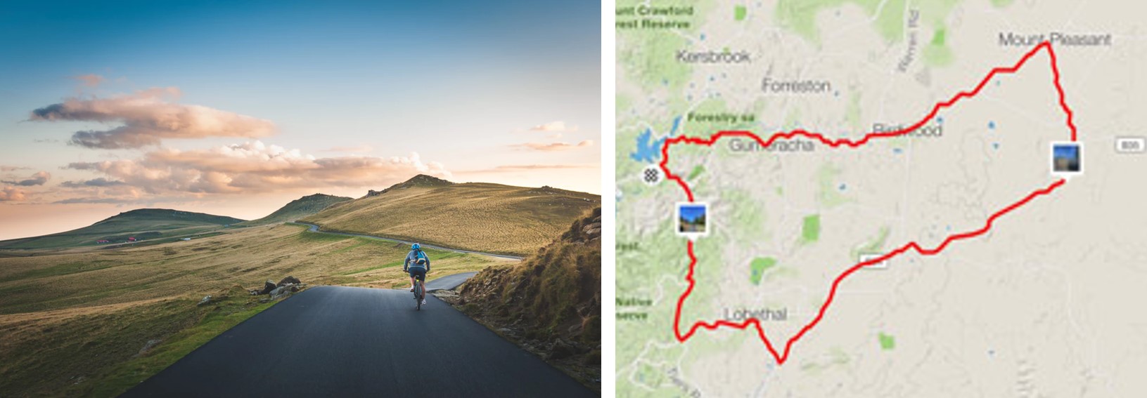
Auto track a cycling trail with GPX export to Strava |
This application can be used by Geocaching players too. Geocaching players can add and tag the points where they find a geocache.
Travelling
 |
 |
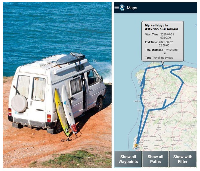 |
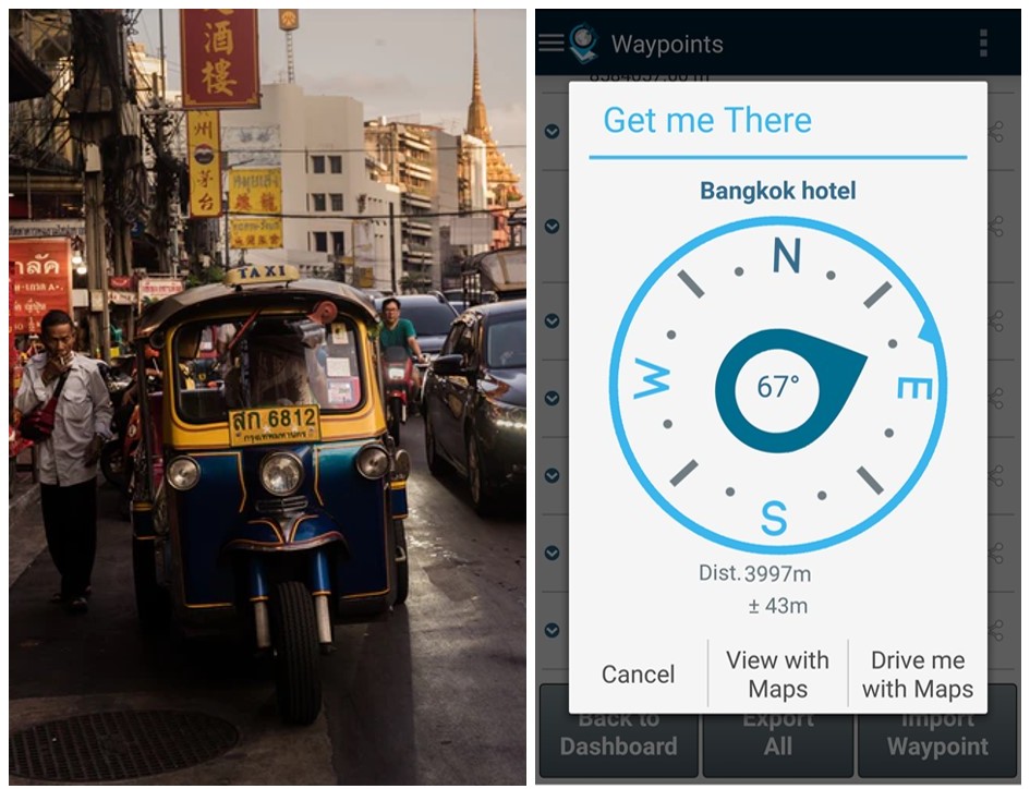
|
| Save the location of your visited places | Save your hotel location and get directions back to it | Record your road itinerary using the Points saved |
Day-to-day life
GPS Waypoints is convenient for mass market users to save their Points of Interests (homeland favourite places, friend’s contacts or just meeting points) and share their locations with someone else (they want to meet) via any messaging application e.g. SMS or E-mail. The meeting person can check the place clicking on the shared URL with place location and check the PoI address (geocode feature). Furthermore, a user can easily send someone else their current location to be found (Find me).
 |
 |
|
| Share your location or meeting point | Save your homeland favourite places and sort them by proximity |
![]()