The GPS Waypoints is a multi sector surveying tool for professional and personal purposes. The application installation, configuration and its main functionalities are described hereafter:
- Installation
- Configuration
- Location and satellites status
- Waypoints surveying
- Paths and Areas surveying
- Backup and Restore
- Upgrade to Premium
- Upgrade to Maps
Installation and permissions
The application requires location, storage and Bluetooth permissions to be fully functional. The location and storage permissions are explicitly requested to the user during the installation process. Each of these permissions targets specific functions, as explained in the figure.
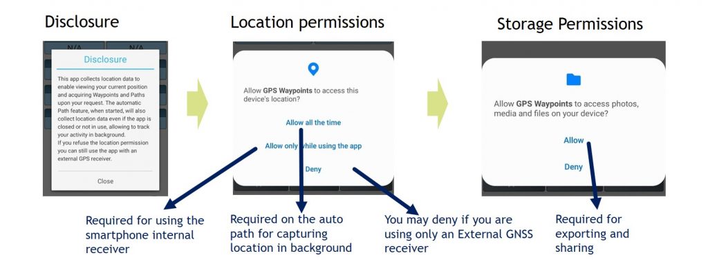
In case, you rejected permissions and you are now facing problems with your current location or geodata exports, you can restore the app permissions on your device Settings.
Configuration
The application can be configured to use either the internal GNSS receiver or an external GNSS receiver. The default configuration uses the internal receiver but it can be re-configured to use an external one.
The internal GNSS receiver configuration takes advantages of the new smartphone’s receivers, with improved accuracies from 1.5 to 5 meters, using GPS and GLONASS satellite constellations. It allows users to perform simple surveying activities using the location service from Android devices. The configuration when using the smartphone’s builtin GPS receiver is presented in the figure.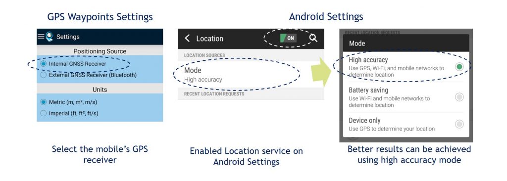
The application also allows professionals to use Bluetooth external GNSS receivers to attain better accuracies (e.g. <1m). Firstly, setup your external device to use Bluetooth connections with NMEA messages and then pair the device with your Android smartphone. Finally, on GPS Waypoints Settings you need to select the “External GNSS Receiver” option and the desired Bluetooth paired device.
Location and satellites status
Current location and satellites available: the application identifies the location provider network (cell tower and Wi-Fi) or gps (satellite), the satellites acquisition status and the information of the current position. The dashboard shows the information of the current position in wgs84 format. The information is calculated from the visible satellites and includes the coordinates, altitude, bearing, speed, accuracy and time of acquisition:
- the Altitude is estimated from ellipsoid altitude representing the current height in meters above Mean Sea Level (MSL) (see example in figure);
- the Bearing represents the GNSS horizontal direction of the mobile device travel;
- the Compass magnetic heading represents the mobile device orientation.
Share My Location: share your current location with another person via messaging application. It could be useful in situations such as meet me on this location or find/help me since I am lost.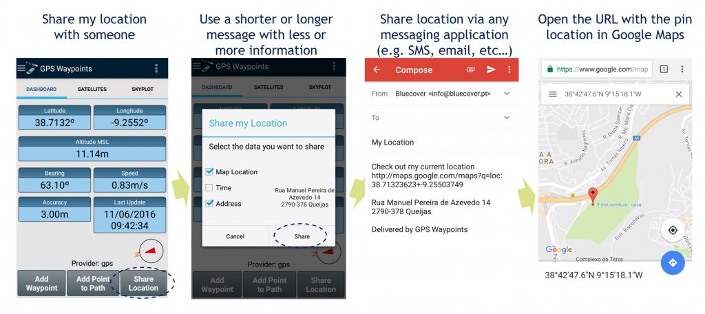
Waypoints surveying
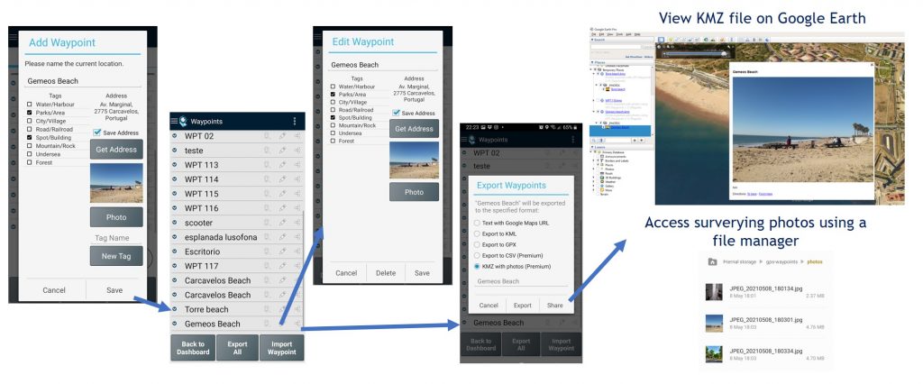
Simple Surveying: you can acquire Points on the field during a surveying activity and build a business or a personal geographic database. The mapping points collected can be exported and shared to other applications (e.g. Dropbox/Google Drive). The Share option is more convenient and popular since the Export option will require access to your device’s internal storage, typically on the folder “/gps-waypoints”. Finally, after getting the exported data, you may view and process it with any geo-spatial tool, such as Google Earth for the general consumers.
Share a waypoint: share your Points with locations with other persons via messaging application (e.g. gmail). It could be useful in situations, such as visit my office on this location, meet me at this coffee shop, check out the issue I found, etc…
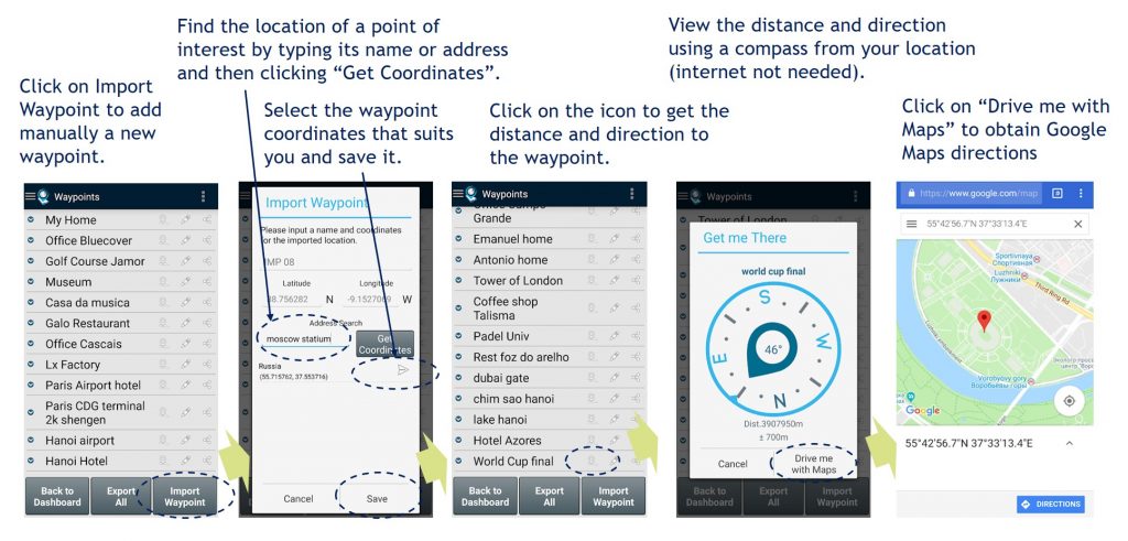
Find a place from a saved Point: you can get directions to Points previously saved and available on your database. It could be useful in situations to go back to the starting point (for instance, when in tourism, you want typically to go back to your accommodation).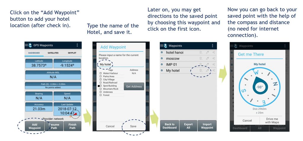 Find a place from a imported Point: you can import waypoints to your database by searching for a Point-of-Interest or for an address. After confirming the search results with the coordinates of the place, you can save it as new waypoint and then check the directions to it.
Thematic surveying with tagging: allows to collect Points and classify them using specific themes (e.g. cartography, environment, urban planning). The thematic surveying uses the tagging functionality that can be customized with the specific thematic data model. The waypoints can be classified according to the data model and can be exported with all metadata to a KML file. 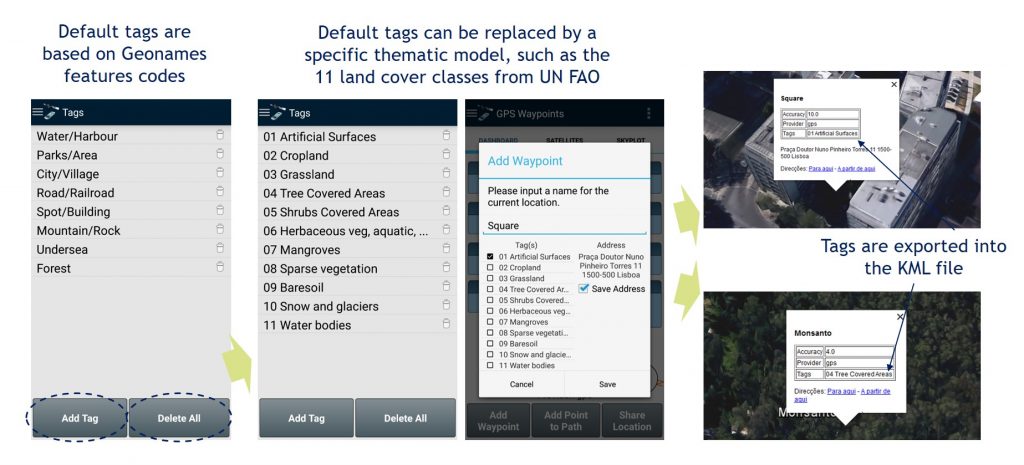 In some surveying activities the mobile precision may be enough but in others, requiring better precision, the application can be connected with an external bluetooth receiver (Professional Survey).
Thematic surveying with automatic tagging (shortcut keys): In Premium mode, it is possible to use an external keyboard and assign shortcut keys to automate the Waypoints surveying activities.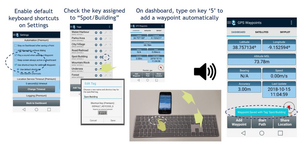
Thematic surveying with photos: allows collecting Points and characterized them with photos (one photo per point). The photos are saved in local storage. They can be exported to KMZ file format (points with embedded pictures) or be accessible using a file manager.
Field Check for insitu observation and validation: you can import multiple points from CSV or GPX file. Visit on the field each of the points imported with the “Get Me There” function and make observations or validation of the previous classification tags (for instance it could be used to validate maps derived from airborne or satellite imagery (Professional validation).
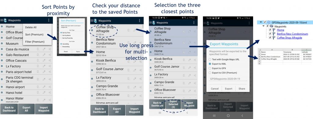
Sort and export the closest Points: you can start by sorting Points by proximity to find the most relevant ones. Then, use the multi-selection feature by long pressing the desired Points to export. Upon completing the selection, just press “Export Selected” button.
Paths and Areas surveying
Manual Path surveying: you can build a Path with an ordered sequence of points and measure the distances of this path (Personal/Professional Surveying).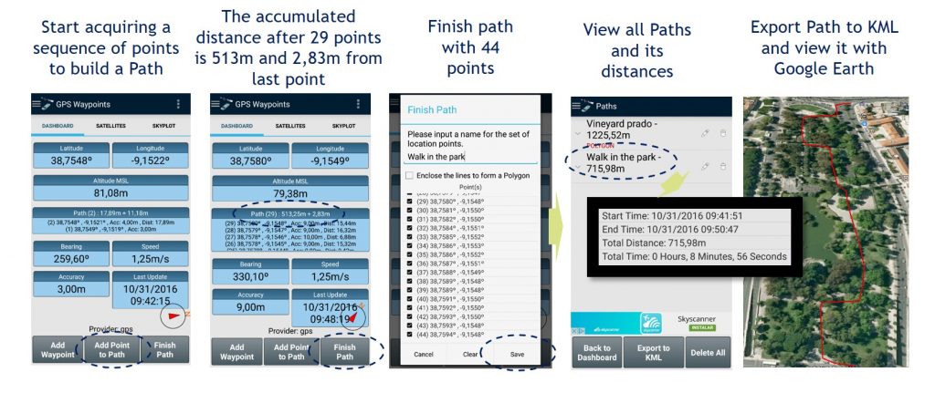
Auto Path tracking: allows to track a moving activity such as bicycle ride, run, car drive or flight, building automatically an order sequence of points (path) and measuring distances of the activity. The exported result in GPX format can be loaded on sports platforms.![]()
Areas surveying: allows building polygons of the land properties on the field and measures their perimeters and areas. When better accuracy is needed (such as in cadastral surveying), an external receiver could be used.
Backup and Restore
The backup and restore of user’s data is a professional feature for saving your work. It is especially useful when acquiring a large number of points or for transferring/migrating data for one device to another.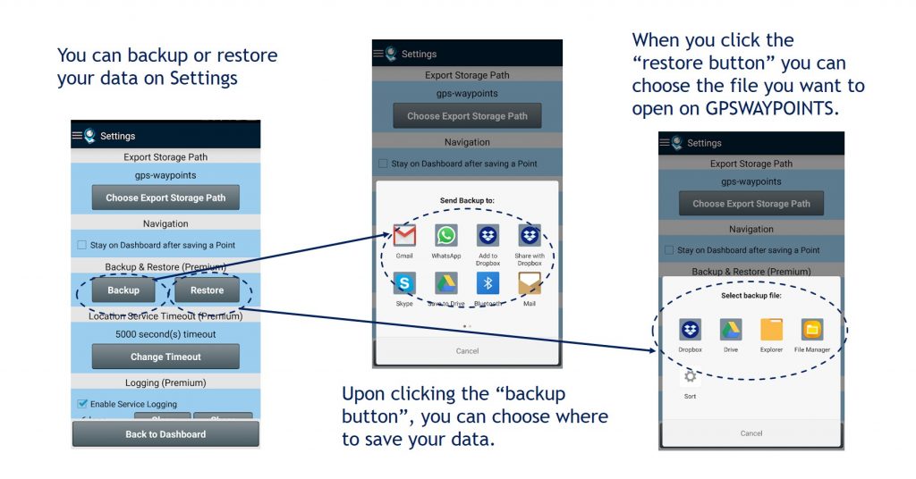
Upgrade to Premium
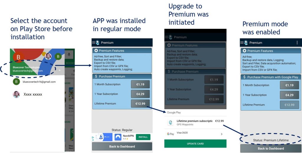
The Premium upgrade is a software activation feature using the free version of the application. It can be performed with Google Play online subscription services or using local license activation paid via Paypal. An example of using Google Play is provided in picture.
Upgrade to Maps
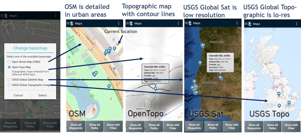
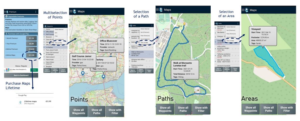
The Maps feature allows the spatial visualization of your geodata, including points, paths and areas . The feature is also a software activation feature upgradable from the free or premium version, using Google Play services. Some examples of the Maps functionality are provided in picture.
The geodata can be visualized using one of the basemaps below. The OSM and OpenTopo can be used with local scales while the USGS bases are low resolution for global scales only.
